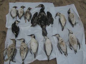
Los temporales en el Atlántico Norte dejan 28.000 aves muertas en las costas y se estima que han caído unas 300.000. Frailecillos, araos y alcas sufren unas consecuencias que se suman a la sobrepesca y los vertidos de petróleo.
http://sociedad.elpais.com/sociedad/2014/03/07/actualidad/1394188621_860112.html
The aim is to establish a monitoring program of Balearic shearwaters Puffinus mauretanicus in Pitiüses and determine their feeding grounds at sea thanks to geolocators within the FAME project www.fameproject.eu. The CONPELHAB project is partially supporting the present conservation project through a network of international collaborators, including Birdlife International partners (LPO www.lpo.fr and SEO www.seo.org) as well as the CEBC-CNRS (www.cebc.cnrs.fr) and IEO (www.ieo-gijon.es).
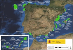 Source: http://www.magrama.gob.es/es/costas/participacion-publica/
 Public consultation on ministerial order declaring 39 Special Protection Areas (SPAs, Bird Directive) for seabirds and 4 Sites of Community Importance (Habitats Directive) in Spain. In recent years, there have been two research projects that have yielded sound research to declare new Natura 2000 protected sites. The LIFE + project "Important Bird Areas (IBA) at sea in Spain ", developed by SEO/BirdLife involving the Ministry and the LIFE + project INDEMARES "Inventory and designation of Natura 2000 areas in marine areas of Spain". The latter project has been coordinated by Fundación Biodiversidadand and has different partners such as MAGRAMA, Instituto Español de Oceanografía, Consejo Superior de Investigaciones Científicas,de Oceanografía, ALNITAK, Coordinadora para el Estudio de los Mamíferos Marinos (CEMMA), OCEANA, Sociedad para el Estudio de los Cetáceos en el Archipiélago Canario, SEO/BirdLife y WWF España.
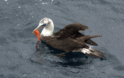
Recently, colleagues from SEO/BirdLife (www.seo.org) published a really interesting paper on the "Incidence of entanglements with marine debris by northern gannets (Morus bassanus) in the non-breeding grounds" in Marine Pollution Bulletin (http://www.sciencedirect.com/science/article/pii/S0025326X1300372X). Rodríguez et al. found that approximately the 1% of all counted gannets showed an entangled plastic debris (mainly red-colored objects). Authors also found that most affected birds were immature, as we were able to observe during the JUVENA survey last September.
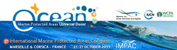
Between 21-25 October 2013, Maite Louzao attended the 3rd International Marine Protected Area conference, http://www.impac3.org/. Every four years, the International Marine Protected Areas Congress (IMPAC) brings together major maritime stakeholders from around the globe, beyond national or sectoral boundaries, to assist in the conservation and sustainable development of the oceans.
Maite contributed with the an interesting talk regarding the identification of ecologically meaningful marine areas in the southern Atlantic waters, using data from predator communities. The protection of key areas for biodiversity at sea is not as widespread as on land and research investment is necessary to identify biodiversity hotspots in the open ocean. Within this framework, we identified hotspots of marine predators in the southern NE Atlantic environment based on the PELACUS ecosystem-based monitoring programme. The PELACUS research survey series is an annual monitoring survey programme that studies the pelagic ecosystems on the southern Bay of Biscay. Based on the small-scale distribution patterns of predators, we identified ecologically meaningful marine areas for marine top predators in this biogeographic area. Understanding the features that determine the distribution of marine predators is a prerequisite for identifying key areas for their conservation, and hence guides the establishment of Marine Protected Areas.
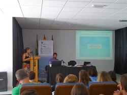 Photo: JL Murcia
 Between 4-6 October 2013, Maite Louzao attended the VI Spanish Cetacean Society meeting in Tarifa, http://www.cetaceos.com/congresosec2013/index.html.
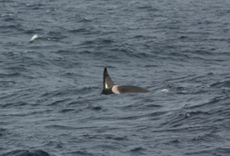
Maite contributed with the an interesting talk about how long-term observer programmes can contribute to conservation and management plans, such as the Marine Strategy Directive Framework. The IEO-PELACUS surveys are conducted annually for acoustic assessment and mapping of the oceanographic and biological conditions of the northern and northwestern shelf of the
Iberian Peninsula. The main objective is to monitor the pelagic ecosystem collecting concurrent information on several trophic levels. Since 2007, marine mammal and seabirds sightings have been recorded by dedicated observers, who also collect information on the type and abundance of different types of human pressures (e.g. fishing, marine debris). Using distance sampling methodology, we were able to estimate the total abundance of marine predator species in the region in addition to mapping the areas where they could be more at risk from anthropogenic pressures such as fishing and marine litter. Our objective is to highlight the importance of observer programmes not only in providing (1) baseline information on distribution and abundance of top predators, but (2) also additional information on human pressures. Both types of data are needed to inform any conservation and management plans such as the MSFD.


 RSS Feed